Xuanzang at the Iron Gates
From “Xuanzang's Record of the Western Regions”,
translated by Samuel Beal (1884),
Discussing this passage, Sally Hovey Wriggins wrote: Xuanzang “turned his face to the south to pass through Shar-i Sabz (Kesh) and an eastern spur of the Pamir Mountains. He entered the famous pass called The Iron Gates, 8 miles west of modern Derbent on the regular trade route from Samarkand to the Oxus and beyond to India. On the Oxus River lay Termez where he found Buddhism flourishing. He notes that there were some 1,100 brethren. As he passed through lands south of the Oxus River (Amu Darya), which nowadays divides Uzbekistan and Afghanistan, he would learn more about Buddhism's chief form of architecture, the stupa, more about the great Buddhist Kings Asoka and Kanishka, and come to know some of the well-known images of the Buddha, such as the giant Buddhas of Bamiyan.
[Source: “Xuanzang on the Silk Road” by Sally Hovey Wriggins mongolianculture.com
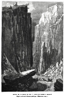
Above: Wood engraving From 'Nouvelle Géographie Universelle, La terre et les hommes', Part VI, 'L'Asie Russe', Édition Élisée reclus, Paris, 1881
In "Record of the Western Regions”, Xuanzang wrote the following regarding the kingdom “Ki-shwang-na [Kesh, Shahrisabz, Uzbekistan]:
“This kingdom is about 1400 or 1500 li in circuit; in customs and produce it resembles the kingdom of Samo-keen. From this place going south-west 200 li or so, we enter the mountains; the mountain road is steep and precipitous, and the passage along the defiles dangerous and difficult. There are no people or villages, and little water or vegetation. Going along the mountains 300 li or so south-east, we enter the Iron Gates. The pass so called is bordered on the right and left by mountains. These mountains are of prodigious height. The road, is narrow, which adds to the difficulty and danger. On both sides there is a rocky wall of an iron colour. Here there are set up double wooden doors, strengthened with iron and furnished with many bells hung up. Because of the protection afforded to the pass by these doors, when closed, the name of iron gates is given.”
“Passing through the Iron Gates we arrive at the country of the Tu-ho-lo. This country, from north to south, is about 1000 li or so in extent, from east to west 3000 li or so. On the east it is bounded by the T'sung-ling mountains (Tian Shan), on the west it touches on Po-li-sse (Persia), on the south are the great Snowy Mountains, on the north the Iron Gates. The great river Oxus flows through the midst of this country in a westerly direction. For many centuries past the royal race has been extinct. The several chieftains have by force contended for their possessions, and each held their own independently, only relying upon the natural divisions of the country. Thus they have constituted twenty-seven states, divided by natural boundaries, yet as a whole dependent on the Tuh-kiueh tribes (Turks). The climate of this country is warm and damp, and consequently epidemics prevail.
[Source: “Xuanzang's Record of the Western Regions”, translated by Samuel Beal (1884), Silk Road Seattle, depts.washington.edu/silkroad |”
Wood engraving From 'Nouvelle Géographie Universelle, La terre et les hommes', Part
VI, 'L'Asie Russe', Édition Élisée reclus, Paris, 1881